Monuments & Memorials on the Antwerp, Yser/IJzer Battlefields & Belgian Coast
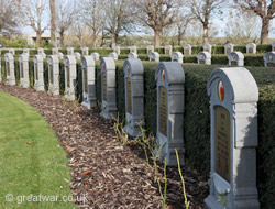
There are a number of memorials relating to the First World War and to missing casualties of 1914-1918 in the region of the Yser/IJzer river and canal and the Belgian coast.
-
Demarcation Stone No. 7, Dodengang
Ijzerdijk (at junction with Dodengangstraat), 8600 Diksmuide
51.045794
2.843002
Latitude N 51° 2' 44.85" ; Longitude E 2° 50' 34.80"
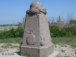
Demarcation Stone located at the site of the only remaining original section of WW1 Belgian Army trenches.
Demarcation Stones mark the point from which the Allied Armies began their offensive in the summer of 1918 and pushed the Imperial German Army to the west, leading to the Allied Advance to Victory and the end of the war.
For information about Demarcation Stones see our page at:
-
Fortress of Breendonk National Memorial
Brandstraat 57, 2830 Willebroek (by car: Rijksweg or Dendermondsesteenweg 305, 307 or 309 in Willebroek)
51.057074
4.341574
Latitude N 51° 3' 27.075" ; Longitude E 4° 20' 30.138"
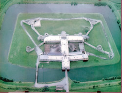
Construction of the fort was started in 1909. It was bombarded for the first time on 1 October 1914 by heavy German artillery under the command of General von Beseler.
Von Beseler was under instruction to take Antwerp and from the night of 27/28 September 1914 it was under siege. The fort was bombarded by over 500 shells over the following days. On 9 October the fort was captured by the German Army.
The Fort was used during the German occupation in the Second World War as an SS Camp. Breendonk Fort was designated as a National Memorial on 19 August 1947. There are exhibitions, educational programmes, and guided visits.
Opening hours:
- Daily (7/7) 09.30 - 17.30 hrs (last admission: 16.30)
- Closed 1 January, 24 & 25 December
Breendonk Fort photo licensed under Creative Commons. (1)
Website: www.breendonk.be
-
HMS Vindictive Memorial
Staketselstraat, Ostend
51.237500
2.924167
Latitude N 51° 14'6.738" ; Longitude E 2° 55' 47.082"
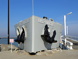
The bow of HMS Vindictive has been preserved as a memorial to the men who took part in the raids by British Naval and Marine Forces on Zeebrugge in April and Ostend in May 1918.
British Naval Raids on Zeebrugge and Ostend 1918
Photograph of HMS Vindictive by Marc Ryckaert and licensed under Creative Commons. (2)
-
IJzer/Yser Memorial
Sluizen, 8620 Nieuwpoort - (N380)
51.134275
2.757815
The monument is a sculpture by Pieter Braecke. It was inaugurated on 26 October 1930. It is located on the banks of the Yser (IJzer) river close to the locks at Nieuwpoort.
-
IJzertoren/Yser Tower
IJzerdijk 49, 8600 Diksmuide
51.031747
2.852336
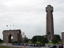
The monument commemorates Belgian soldiers, many of whom were Flemish, killed on the Yser battlefront in the First World War. The first IJzer Tower was built in 1928 and inaugurated on 24 August 1930. It was destroyed in March 1946 by people unhappy about the collaboration of some Flemish people with the Nazis during the German occupation of Belgium.
A second tower was built on the site from 1951 and was completed in 1965. It carries the letters AVV-VVK (Alles Voor Vlaanderen, Vlaanderen voor Kristus). This translates as “All for Flanders-Flanders for Christ”.
The tower is an important place in the history of the Flemish Movement and Flemish Nationalism. At 84 metres high the tower is the tallest peace monument in Europe. The 22 floors of this monument house a museum.
Photograph: "IJzertoren" by Willemdd from nl. Licensed under CC BY-SA 3.0 via Wikimedia Commons - http://commons.wikimedia.org/wiki/File:IJzertoren.jpg#/media/File:IJzertoren.jpg
-
King Albert I Monument
Kustweg 2, 8620 Nieuwpoort - (N34)
51.135868
2.755852
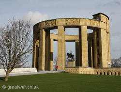
The King Albert I Monument was constructed in 1938 to pay hommage to the Belgian King. It is located on the banks of the Yser (Ijzer) river at Nieuwpoort. The opening of the lock gates at Nieuwpoort played a key role in the Belgian defence during the autumn of 1914.
Access to the external part of the memorial is available at all times. Access to the stairs inside the memorial to climb up to the balcony around the top of the monument is available during opening hours of the visitor centre.
See:
-
Nieuport Memorial to the Missing
Kustweg 2, 8620 Nieuwpoort - (N34)
51.136938
2.755637
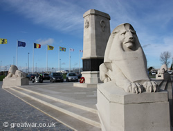
The memorial commemorates 566 British and Commonwealth officers and men who have no known grave. They were killed during actions on the Belgian coast during the First World War.
For further information about the British and Commonwealth War Graves and the memorials maintained by them visit the website of the Commonwealth War Graves Commission:
Website: www.cwgc.org
-
Nieuwpoort War Victims Monument
Onze Lieve Vrouwstraat, 8620 Nieuwpoort
51.128464
2.750176
The monument is a sculpture by Pieter Braecke. It commemorates the war victims of the town of Nieuwpoort from the First and Second World Wars. It is a mourning woman with names of the victims inscribed on small crosses at her feet.
-
Onze-Lieve-Vrouwehoekje
Oud Suivekens, Stuivenskerke (north of Dixmuide)
51.058837
2.832190
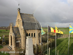
Latitude N 51° 3' 31.81" ; Longitude E 2° 49' 55.88"
This has been a designated memorial site since 2005. It features: a chapel built on the site of a demolished church since 1870, the ruined and now preserved west tower of the former church, a command bunker and memorial plaques.
From 3 November 1914 the church tower was used as a look-out post and the place was an important watch post in the Belgian defensive line between the Yser Canal and railway. It was one of the few places where the Belgian Army could get high up to see across the flat landscape all around and to look across to the German positions on the other side of the Yser Canal. Throughout the war the post was occupied by about 100 soldiers. This was the southern of two watch posts in the Stuivenskerke area. The northern watch post was called Reigersvliet.
The memorial chapel was built after the war after an the idea of Martial Lekeux, who was an observer based at the watch tower in 1914-18. A platform with an orientation table has been built in the tower so that visitors can see across the old Yser battlefield.
A Demarcation Stone at the site also marks the point of the furthest German advance.
-
Zeebrugge Memorial
Sint Donaasstraat, Zeebrugge
51.332127
3.207450
The Zeebrugge memorial is an engraved stone built into the wall of the Zeebrugge Churchyard cemetery. It commemorates four British servicemen who died on 23 April 1918 during the British raid on the port.
Zeebrugge Memorial
Related Topic
Cemeteries
There are military cemeteries for Belgian, British & Commonwealth and German First World War casualties.
Cemeteries on the Yser Battlefields & the Belgian Coast
Acknowledgements
(1) Photo of Breendonk. Used under license of Creative Commons:
Website: https://commons.wikimedia.org
(2) Photo of HMS Vindictive by Marc Ryckaert. Used under license of Creative Commons Attribution 3.0 Unported
Website: https://commons.wikimedia.org
